First Snowflakes of the Season, Dangerous Cold, and then More Snow?
Delmarva saw its first snowflakes of the season today. Radar lit up with the white stuff around 8am and it continued through midday. Below is a look at the 9am radar map showing bands of snow showers moving through the area.

Western areas saw snow showers and flurries more frequently while other areas such as Salisbury only saw a few flurries at times. For some, if you blinked, you may have missed it. But it sure did look like winter in some areas today with the snow.
Not only did it look like winter, it felt like it too. Temperatures will stay in the 30s Monday and Tuesday with breezy winds creating cold wind chills in the 20s during the day and single digits at night. The very top picture in this article shows how cold it will feel Monday night across the region. I am considering this dangerous cold because it is the first real arctic outbreak of the season and we aren’t quite used to these very cold temperatures. Please check on the elderly, the less fortunate, and those who may not have heat in their homes, and dress warmly yourself. Conditions don’t really improve until Wednesday when warmer air begins to move in. Highs should rise into the 40s and 50s for the rest of the week and through the weekend. Below is a look at the ridge expected to move in. The map is showing higher heights which will bring in warmer air for the regions in red.

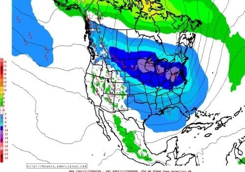
Rain is expected to move in along with the warmth. The first system looks to be Friday night into Saturday producing all rain. The next one looks to be Sunday night into Monday with mostly rain as well, and then after those two systems we need to watch the arctic air expected to move into the area once again. This cold air could meet up with another storm which COULD bring some snow. What we know now is that the pattern is turning stormy and colder. Snow chances will increase but that doesn’t mean it will snow for sure. We will have to continue to watch the upcoming pattern. Below is a look at a map that shows lower heights moving in after January 13th. The areas in blue will be colder than normal.

Another image of a forecast model is below, it is showing the arctic air filtering into the U.S from Canada and heading east by the middle of the month. It also shows below normal temperatures for the areas in blue.

Computer models are in great agreement that January will turn much colder by mid month. I am confident that they have a good handle on this. But the upcoming pattern is complex and the computer models will not do a good job forecasting individual storms, so we will have to keep a close eye on the models in order to keep you all informed on possible snow chances. If you’re a winter weather lover, I would get excited because the pattern is looking much better than December.