Satellite View of Flooding in South Carolina
During the first days of October some parts of South and North Carolina had 15-20+” of rain. From October 1-4, Charleston, SC received 17+” or rain, Downtown Charleston had more than 16″, Columbia had 11″, and Myrtle Beach received 14.” This historic rainfall event set new records for the greatest 1-day, 2-day, 3-day, and 4-day rainfall totals in Charleston and Columbia.
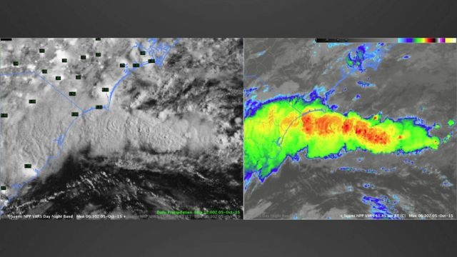
Here is a satellite view of these events. These images are from October 5th at 2:30 AM local time and overlaid is the 24-hour precipitation for the period ending on October 5th 8 AM. The black and white image shows some areas along the coast receiving more than 6″ of rain in that 24-hour period, after the area had already received a lot of rain.
The area of clouds shown in the images illustrate a band of strong convection offshore that was moving inland and causing the flooding event. The “bubbly” areas indicate convection in the black and white image.
The colored image highlights the areas of high cloud tops or overshooting tops. Infrared images show cloud top temperatures by measuring the radiation emitted from the clouds. High clouds are cold, mid-level clouds are relatively warmer, and low clouds are even warmer. In this image, with this particular color scale, the red areas show the cold clouds.
Now comparing the images, the “bubbly,” convective areas in the black and white image match the areas of red/orange, high, and cold clouds.