First Dates of Snowfall
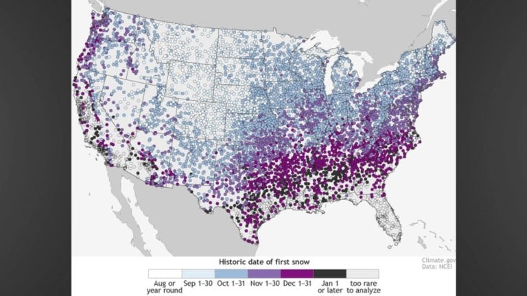
Deke Arndt from the National Centers for Environmental Information did a study on the first dates of snowfall based on patterns from 1981-2010. The dates that the map shows indicates the date by which there is a 50% chance that at least 0.1 inches of snow will accumulate.
The basic patterns show that the factors that govern major climate characteristic also govern the average day of the first snowfall, which is latitude and altitude. In general the farther north you are and the father up you are, the earlier you might see snow. There are some areas, such as the highest elevations of the Rockies that have the threat of snow all year long. On the other hand, places in the Deep South, Gulf Coast, Desert Southwest, and Hawaii have areas that rarely get snow (empty circles) and do not have enough events to make an accurate conclusion.
On the map there is a pattern across the Plains and Midwest that has a slight northeastward tilt, instead of an east-west patter. This is most evident from the Texas panhandle to Illinois, near Chicago. This is mainly associated with the coldest air from winter storms that often moves through the high plains. There is also another northwestward tilt above the one just mentioned with a light purple shade, peeking south from the Great Lakes, which can be associated with winds picking up moisture from the lakes that have still relatively warm waters.
Now for us here on Delmarva, we have a mix of indicated first dates of snow fall based on the historical patterns. It ranges from Nov 1-15 and Nov 16-30 and there is one outlier on the southern part of the peninsula that has the first snowfall for Dec 15-31.
We are very close to missing the category under Nov1-15 and with a strong El Nino; it is likely that we will miss the second category from Nov 16-30 as well. Last winter 2014-2015, the first snowfall with more than a trace of snow recorded in Salisbury was on February 14, 2015 with 0.5 inches. Two winters ago 2013-2014, the first date with more than a trace was January 04, 2014.
We have to remember that this study is based on 29 years of data starting in 1981 and ending in 2010. There are many years in between that do not have readings from all stations on Delmarva. This map really teaches us a basic pattern of first snowfall dates across the United States.
You can see the full post about this data here:
https://www.climate.gov/news-features/blogs/beyond-data/first-dates