Mid-Winter Update: What to Expect Next…
The winter of 2015-2016 has been a dud so far for the snow fans out there. The lack of snow is honestly driving some people nuts, while others are enjoying the lack of snow. After all, the past two Delmarva winters (2013-2014, 2014-2015) were pretty harsh with cold temperatures and above average snowfall.
Let’s talk about the rest of the winter and whether we expect to see any changes, or will it be more of the same?
TELECONNECTIONS: These are typically huge factors when it comes to the winter. Meteorologists look at these teleconnections as signs and symbols that help give clues on what to expect. There are three that are followed the most; they are the North Atlantic Oscillation (NAO), Arctic Oscillation (AO), and Pacific North American Index (PNA). The NAO and AO are measured by the different types of pressure that occur in the North Atlantic and Arctic Oceans. The PNA is a measure of the circulation pattern over the north Pacific.

A +PNA, -NAO, and -AO typically mean that the east coast will be cold, while the opposite means it’ll be warm. The red lines in the graph above are where the models expect the teleconnection to go in the future. Notice in the graph above, the indices are just where they should be for a cold east coast. They’ve been that way since about January 1st and that’s exactly why our pattern went from record warmth in December (-PNA, +NA0, +AO) to a colder/more normal pattern now. The only thing is there hasn’t been a storm to bring snow.
EL NINO: El Nino events are extremely volatile patterns and everything really needs to come together perfectly, especially during strong El Nino years like this year. In the past, strong El Ninos have brought above normal snow and below normal snow to Salisbury. It can actually go either way. Check out the chart below, it shows the amount of snow that fell during the past 6 strong El Nino winters in Salisbury (SBY). Chart courtesy of the NOAA Wakefield, VA office.

Three years had well below normal snow and three years had above average snow. So there is no perfect snow correlation for strong El Nino years; it usually depends on other factors like teleconnections, etc. But when you average it out, Salisbury usually ends up with around 8.9 inches for the winter which is around average to slightly below average. This goes to show how hard it is to make a winter forecast during a strong El Nino. There isn’t really a high correlation for temperatures either, they usually average out to about normal, but some years were above and some below.
The 47ABC Storm Team predicted an average winter in terms of temperatures and a slightly above normal snowfall season of just around 12 inches. So far we are above normal for temperatures and below normal for snow. It’s not looking good for our forecast, however we did say that the second half of winter would be the coldest and snowiest while the beginning would start slow, which is the case so far. But no one expected that insanely warm December of 12 degrees above average.
With half the winter season to go, things can still turn around. We believe that February and March will be Delmarva’s snowiest months with perhaps one big snowstorm (greater than 4 inches). That’s one reason we went above normal for snow because the chances of getting a bigger snowstorm this year were high. Why?
El Nino winters bring a strong southern jet stream which usually draws in a lot of moisture. When the jet stream is active and the teleconnections are just right then a coastal snowstorm can occur. This is the main reason for the above average snow seasons in previous El Nino years. Right now the teleconnections are just right, but that doesn’t necessarily mean there will be snow, everything has to align perfectly.
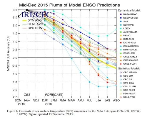
The El Nino has been slowly weakening overall for the past few weeks as expected and it should continue to weaken through the rest of winter and into spring. You can see the forecast models showing the Nino drop off.

The weakening can also help bring cold and snow chances to our area because the stronger the Nino the better chance of warm Pacific air ruining our snow chances which seems to be a bit of the problem this winter.
As stated before, the current teleconnections are perfect for a cold east coast and that looks to be the case heading into next week. The coldest air of the season will arrive. Model data supports this as you can see by the Canadian model below. It shows cold air anomalies over Delmarva.

But if you noticed in the teleconnection section above, it shows the PNA remaining positive, but the NAO is trending towards neutral and positive which historically has brought a snowstorm to the region. So as it trends more positive we should watch out for a possible storm between January 21st-25th. But once it goes positive, which it might, that usually means it would bring some mild air by the end of January. This also has model support as you can see by the Canadian model below showing warmer than average temperatures.

So in conclusion, the atmosphere is a mess. Honestly, it’s very hard to forecast during an El Nino, for both long term and short term forecasts. One small change in the atmosphere can make everything else change dramatically. El Nino has a big grip on this winter and its influence is outweighing other factors right now. That’s why we love forecasting though, it’s a big challenge. So here’s my challenge; do I give up on winter and say that our forecast is wrong, or should I stick to my guns and say the rest of the winter will bring snow?
When I first started forecasting for the winter my gut was saying, “Daniel, you know it’s very rare to get three winters in a row with cold and snowy conditions on Delmarva, plus the last time we had a Nino this strong it was a mild winter.” So that initial gut feeling is scaring me, but at the same time all Ninos are different. And I saw other signs such as the active southern jet stream that made me think we would see better chances for snowstorms, and I still believe that. I believed that the teleconnections would favor our region which they have so far in January. That’s where I am not 100% confident; will the teleconnections stay favorable into February and March? It’s tough to say but I think so overall. As the Nino weakens and we start to see more changes in the atmosphere, things should get better for snow lovers. Also, statistically, the end of El Nino winters are the snowiest anyway. By no means will it be an extremely snowy winter or a very cold winter, we never thought that. But we still think we can reach average snowfall or at least close to it. We already have an active southern jet stream now, we just need things to come together and they might, so stay tuned…