ENSO: Now in a neutral phase, possibly turning into La Niña
We fell into a neutral ENSO phase in June and according to NOAA, sea surface temperatures so far this month are between -0.5ºC and 0.5º away from the average in the Niño3.4 region.
So far we are neutral, meaning sea surface temperatures are not above or below average, they’re right in the middle. Once they constantly stay -0.5º below the average, we officially go into a La Niña phase.
Last month, the probability of going into a La Niña phase was 75% but this month it has dropped. The probability has now changed to 55-60% of going into the phase in the fall. Even though chances have dropped, forecasters believe that it is more likely than not that sea surface temperatures drop -0.5º below the average. At this point, it’s deciding whether or not it becomes a strong La Niña.
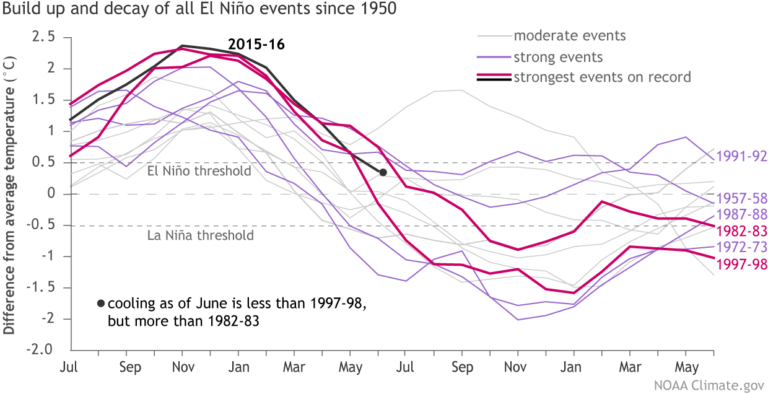
We just got out of one of the strongest El Niño phases on record, and history shows that almost always a strong La Niña follows. So, comparing it with other strong El Niño phases, the image above shows that the 2015-2016 sea surface temperatures stopped dropping as quickly between May and June. At the same time, other strong El Niño phases showed that monthly fluctuations may not mean much.
This all meaning, forecasters are not sure yet. They believe models have changed probability due to the lack of enhanced trade winds. These enhanced winds help push colder than average water in the east towards warmer water, where they measure for El Niño/La Niña.
To keep up with the forecast, click HERE. To read the blog by Anthony Barnston on this subject click HERE.