An analysis and recap of tropical storm Ophelia
Here we’ll discuss the beginning of what would eventually become Ophelia, examine its journey toward Delmarva, and the impacts that it left on us. At the end of September, we are still in a climatologically active part of hurricane season. Additionally, transitioning into Autumn is also the time when we start seeing an increase in non-tropical low-pressure systems developing in the mid-Atlantic and northeast (you may have heard some of these storms referred to as nor’easters). Generally, in Autumn, you will have a pure tropical *warm core* cyclone transition into non-topical *cold core* cyclone as it travels to higher latitudes, and that’s what happened with Ophelia.

The frequency of tropical cyclones based on climatological data
The origins of Ophelia began as a cluster of showers and thunderstorms firing up along a stalled frontal boundary in the Caribbean. This eventually evolved into a wave of low pressure along that same boundary. The trigger to begin pulling it northward was a dip in the subtropical jet stream (band of strong winds ~30,000 ft aloft around the 30° latitude line) in a NW to SE orientation (aka in a negative tilt).

The initial setup of Ophelia’s early stages
Our wave of low pressure was captured by the jet stream and was then able to start its trek northward, and it did so on Thursday. But we’ve already mentioned two features that would, at least at the time, prevent the National Hurricane Center (NHC) from classifying this as a system as tropical in nature. It retained its frontal features and had interaction with the jet stream, which are more reminiscent of non-tropical low-pressure systems than tropical cyclones, which do not feature fronts (i.e. a warm front, cold front, occluded front) and are not dependent on the jet stream for maturation, unlike non-tropical cyclones. So instead of referring to this disturbance as Tropical Depression 16, it was instead referred to as Potential Tropical Cyclone 16. Fronts and the jet stream are associated with horizontal temperature gradients, which are part of a cold core system. For this disturbance to be classified as tropical, it would have to remain over the warm waters (80°+) long enough to achieve a warm core center, a prime characteristic of tropical cyclones and a differentiation from non-tropical cyclones, to become the next named storm of the current Atlantic hurricane season. And it did just that.

With the path shown in white, PTC 16 traversed over 80°+ water long enough to become a tropical storm just before landfall
Tropical Storm Ophelia was officially named on Friday, September 22nd at 2:00PM, sitting around 150 miles SE of Cape Fear North Carolina. Its center circulation made landfall near Emerald Isle in North Carolina on September 23rd at around 6:15AM with sustained 70mph winds and a minimum central pressure of 981mb. While this was declared a named tropical storm, it really was technically a hybrid tropical/non-tropical system. Tropical cyclones have the heaviest precipitation and strongest winds focused at the center, while non tropical cyclones have a much expanded rain and wind field (mainly due to the influence of the jet stream interaction). Ophelia essentially had the inner core of a tropical cyclone with an expanded rain shield reminiscent of a non-tropical cyclone.

Ophelia makes landfall in North Carolina
In Delmarva, winds started picking up Friday and peaked through the overnight into early Saturday morning, which is around when most of our highest wind gusts were reported. This was mainly because of a strip of very strong winds about 4,500 ft aloft (known as a low-level jet streak) that passed by at this time and was able to mix down to the surface via heavy downpours as strong wind gusts. This jet streak passed north of Delmarva Saturday afternoon, hence why winds were not as strong by then. As expected, our eastern shores observed the highest wind gusts mainly peaking around 50-60 mph. Although Lewes was indeed an outlier, reporting a 64-mph wind gust at 7:30 AM. Inland wind gusts ranged in the 30-40 mph range. The northeasterly winds in combination with the high tide cycle Saturday afternoon also pushed coastal flooding into not only the eastern shores, but also parts of the western shores by bay as well, mainly in southwestern Delmarva. Many across the eastern shores and southwestern shores reached moderate flood stage during high tide, with coastal locations in Kent (Delaware) and Sussex counties reaching near major flood stage.

Peak wind gusts observed on Saturday
Rainfall amounts across Delmarva generally ranged from 1-4 inches, with lower amounts in northwestern counties. Sussex county received the highest totals, with many station reports over 3.50” of rain. The highest observed report was in Harbeson, Delaware at 3.73″.

Listed are some of the highest rainfall totals observed in Delmarva
A threat that was heavily monitored Saturday afternoon was for potential tornadic activity. On the northeast quadrant of a tropical cyclones, that’s where the greatest direction wind shear (change of wind direction with height) is focused at. Through the afternoon, a compact mass of unstable air (warmer and humid air relative the current surroundings) invaded southern Delmarva but didn’t make it much further than north of Wicomico and Dorchester counties. What unfolded as a result was an environment that allowed for storms to grow and try to tap into the directional shear in southern Delmarva, only for them to weaken and collapse when moving into the stable air before maturation in these developing thunderstorms can take place. Fortunately, this means that the tornado threat did not come to fruition. Notice the organized line of thunderstorms in the unstable air with the overshooting cloud tops.

Air was unstable in southern Delmarva, but stable in northern Delmarva
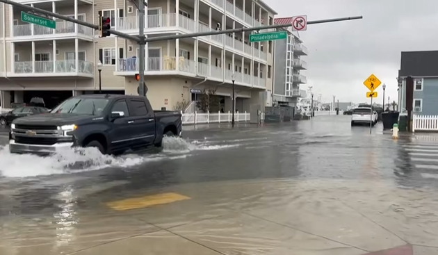
Damage was certainly done in Delmarva both from wind and coastal flooding. In Ocean City, a roof was blown off a condo Saturday morning. Millsboro, DE, saw flooding estimated to be a few feet deep surged in from the Indian River Bay, and a report of a large tree down across a driveway came from Lincoln, DE. At Dewey Beach, coastal highway route 1 southbound had to close due to coastal flooding. We also had photos sent in of severe coastal flooding that occurred in Crisfield, MD, and Tangier Island, VA. Crisfield suffered significant coastal flooding during the two hide tide cycles on Saturday and during the evening high tide on Sunday.

Coastal flooding from Saturday evening in Crisfield

Coastal flooding shot from Crisfield early Sunday afternoon (Credit: David Barone)

A roof in Ocean City ripped off by the wind Saturday morning
As of Monday, September 25th, what once was Ophelia has since transitioned into a non-tropical low-pressure system, losing any tropical characteristics it had. This transition does not always mean a weakening system, but in this case the system has weakened considerably.

The remnants of Ophelia off the coast as a weakened non-tropical low pressure system