Winter is back: Snow, ice and rain all possible this week on Delmarva
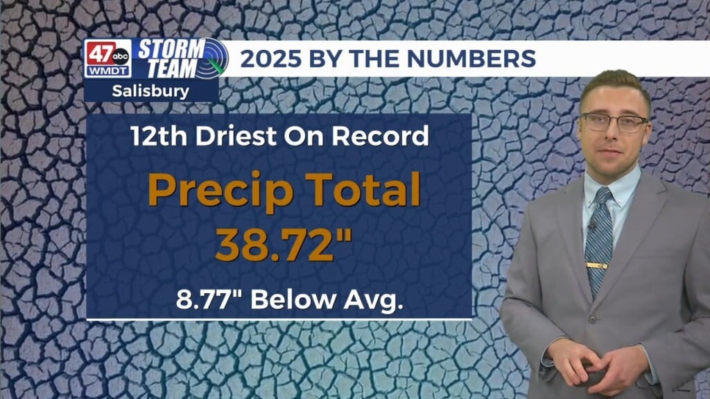
As expected, (and just like the groundhog promised!), winter is far from over on Delmarva. The coming week will feature what’s likely to be an accumulating snow event for much of the peninsula, followed up by another quick moving storm that may be more of a rain maker. Together, these storms will help chip away further at the persistent drought that still plagues the area.

A Winter Storm Watch is already in place for Tuesday afternoon through Wednesday for all of Delmarva, extending back into the DC and Baltimore metro areas. Probabilities of a 4″+ snowfall are increasing for much of the area, especially for areas along and north of US 50.

The setup is similar to our previous snow events from last month. A blocking high to the north will keep the storm track south of the area. This will allow the deep cold air needed for snow to stay wedged into the region as precipitation moves in from the southwest on Tuesday. In this setup, heavier snow would last longer across much of the area, with the ice/mix line pushing into southern Delmarva on Wednesday. The ice/rain line would stay further south for much of the duration of the storm.

But similarities to the big snow and arctic aftermath of last month end there. There won’t be a transport of deep arctic air behind the storm as the blocking high won’t be in play for the second storm on Thursday. This will allow for a more northerly storm track along with milder air to surge further north ahead of the storm and would suggest a mostly rain event for Delmarva, with the ice and snow threat shifting well north of the area. 
Overall, the second storm brings an opportunity that would be a beneficial to the region to combat the significant drought that still exists. Unlike last month, when the frigid and incredibly dry air allowed for sublimation to occur (snow/ice pack skipping the melting process and becoming water vapor), the melting process would be more pronounced this time around with the milder surge of air and potentially heavy rainfall. Isolated flooding would be a possible concern, but it doesn’t appear enough rainfall would occur to create too many issues. The downside will be a wet and muddy several days lasting into the weekend and the following week.