Near-Record to Record Warmth Dominated Delmarva for Winter 2022-2023

The two biggest takeaways of this past winter on Delmarva; was the abnormal warmth and the unusual lack of snow. Temperatures across Delmarva especially for the 1st two months of 2023 have been within the top 5 warmest on record.

Meteorological winter began in December and the month was slightly below average; when it comes to temperatures in Salisbury and Georgetown. 60% of the month (18 days) were below average for temperatures in Salisbury. The coldest day of the month was Christmas Eve during the Arctic blast; which produced a record cold high for Georgetown & the 2nd coldest high for Salisbury, as highs hover 20°.

January & February were deep contrasts to December; where temperatures were well above average each month by at least 6°. Georgetown experienced its warmest January & 3rd warmest February on record. Salisbury had its 4th warmest January & 5th warmest February on record. The record and near-record warmth of the 1st 2 months of 2023; led to Salisbury having its 2nd warmest winter, while Georgetown experienced its warmest winter on record.


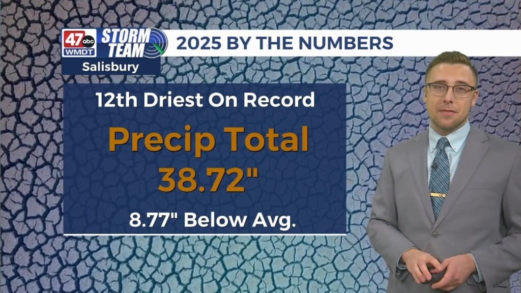
Precipitation specifically rainfall ranged from above average in December to below average in January & February. Luckily, drought conditions have stayed constant most of the winter; with drought concerns contained into Accomack County. The wettest day of the season was back on February 15; where both Georgetown & Salisbury saw amounts on either side of 2″ which is also more than what was recorded in January & February, respectively. Snowfall this season has been nearly nonexistent with trace amounts recorded for Salisbury & Georgetown; with a few locations north of Georgetown observing amounts up to half an inch on February 1st.


The reason for the abnormal warmth and lack of snowfall this winter; is mainly due to the jet stream & storm system pattern. Storms this season have been cross country from the Pacific towards the Atlantic; which only brings cool air and not cold air from the Arctic. The air just ahead of these systems is warm air from the Gulf of Mexico; that has catapulted our temperatures well above average. Once, the front passes through Delmarva; the cool Pacific air brings our temperatures down back to seasonable levels or slightly below average. Also, the storms have had their low pressures centered over the Great Lakes and Appalachians instead off in the Atlantic or along the coast. This setup keeps Delmarva on the warm sector of the storm, producing rain. Also dry air from the cold fronts arrived quickly, inhibiting any chance of a changeover to snow.

An interesting pattern of this winter season was the timing during the week of when the warmth & coolness arrived on Delmarva. The weekly setup for most of the season involved an early week warmup; followed by the warmest temperatures occurring late in the week. This will conclude with a frontal system late in the week, especially on Friday; with the coolest temperatures observed during the weekend. Temperatures were warmest on Thursday by 10° above average; while Saturday would tend to be the coldest day of the week being over 1° below average. This situation led to Friday being the transition day and midpoint average of the two extreme days of the week. Wednesday was the 2nd warmest day; while Sunday was the 2nd coolest day of the week.