Today’s Forecast: October 28, 2021
** Coastal Flood Advisory in effect until 10 AM Friday. **
** Coastal Flood Warning in effect until 6 PM Saturday. **
** Wind Advisory in effect from 7 AM to 7 PM Friday. **
Tonight will be mostly cloudy with lows in the upper 50s. Showers will begin after midnight, becoming more steady by dawn.
Periods of rain can be expected Friday under cloudy skies and windy conditions. Easterly winds will gust between 35-45 mph for inland areas, with gusts higher than 50 mph at the coast. Coastal flooding is the biggest concern, with low-lying areas being especially vulnerable. An isolated thunderstorm is possible as well. Showers will taper off during the evening and early night.
Saturday will be partly sunny with highs in the mid 60s and the chance for a few showers. Halloween turns mostly sunny with highs in the mid 60s.
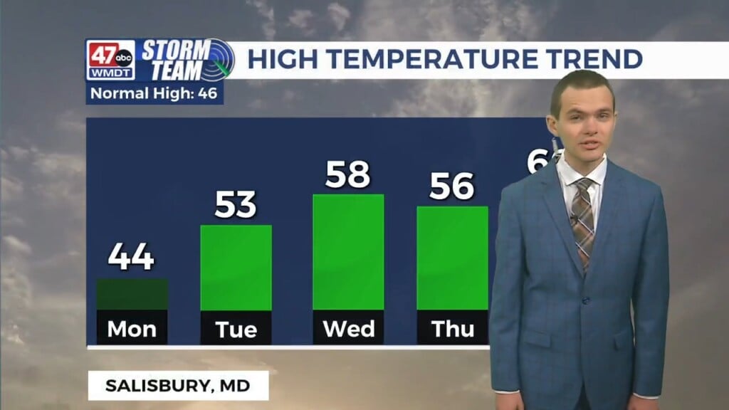
Monday will be sunny with highs in the low to mid 60s. Tuesday, partly to mostly sunny skies are expected with highs in the low 60s. An isolated shower cannot be ruled out late.
Temperatures plummet into the 50s to near 60 on Wednesday behind a cold front. Partly sunny skies are expected. Partly sunny skies continue into Thursday with a chance for showers. Highs will only be in the 50s.
Have a great night!
-Daniel