Tropical Storm Hermine: Its Impact on Delmarva
Changing weather is expected on Delmarva as we head into Labor Day weekend. Tropical Storm Hermine could strengthen into a Category 1 Hurricane later today and make landfall along the coast of Florida tonight. Where the storm goes from there will determine our weekend weather.
The National Hurricane Center (NHC) posted its latest advisory at 7 AM. It takes Hermine up the east coast just off Delmarva over the weekend and weakens it to a post-tropical storm. At this point, it becomes more of a hybrid system, kind of like a Nor’easter with slight tropical characteristics. A post-tropical storm can still bring flooding rains and strong winds. “Superstorm Sandy” back in October 2012 was a post-tropical storm and it caused catastrophic damage in some parts of the U.S. Not to compare this to Sandy, but just using it as an example.
Yesterday’s afternoon model runs brought the remnants of Hermine up the coast and pretty far inland, bringing strong winds and very heavy rain to Delmarva all weekend long. Last night though, the models shifted everything about 100 miles or so to the east, which would mean our area would see a little less rain and wind. Below are a few of those model runs keeping the heaviest rain offshore, but still bringing our area some rain.


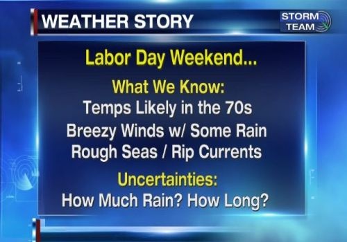
So the question is, which set of models are correct? Either way, it looks like part of the weekend will be breezy and wet. I’m thinking Delmarva will see rain, heavy at times, especially along the immediate coast. The rain will begin around midday Saturday and continue until midday Sunday before slowly tapering off. There could be some lingering showers into Monday as some computer models stall the system close enough off the coast where more rain could build back into the area. So here’s what we know:

Things are still a bit uncertain with how much rain will fall and whether it will continue for the entire weekend including Monday. Right now we’re fairly confident that parts of Saturday and Sunday will be wet. The other details still need to be worked out.
Some of the biggest concerns with this storm will be gusty winds and coastal flooding. With a strong post-tropical storm off the coast, easterly winds are expected for a few days. Easterly winds will cause a build up of water and push it onto the coast, creating flooding concerns. Life-threatening rip currents are likely and waves will be abnormally large. Some of the latest information is showing that winds could gust as high as 60 mph along the immediate coast.

While winds could gust to 60 at the beaches, inland areas could see gusts to 40 mph, but it all depends on the exact track of this storm. Almost everything depends on its track. Tropical Storm force gusts are likely on Delmarva, but the chance of the area seeing sustained winds of tropical storm force are still low.

This continues to be a difficult forecast and we’ll continue to iron out the details for you as more data continues to come in. I expect a few more changes before all the information is known. Right now, I like the NHC’s latest 7 AM track of Hermine, with the storm possibly staying a bit closer to the coast than what they’re forecasting. The pattern seems to favor a coastal hugger due to very warm waters off the coast, ridging just to our east, and a trough digging in to our west. That should help pull the storm close to the coast. I’m not expecting the storm to stay inland or west of our area. What we don’t want is the storm to stall out and sit there for days, and that is still a possibility that some models are showing. That could keep coastal flooding going for days on end and create more unfortunate beach erosion. Stay tuned.