El Nino is starting to weaken, what’s next?
Water temperatures in March show El Nino at the initial stages of weakening and forecasters are expecting water temperatures to drop below the El Nino threshold in the late spring or early summer.
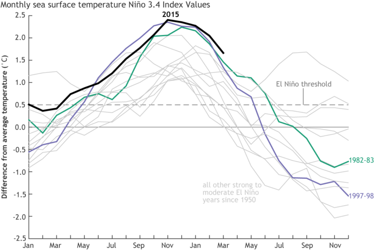
As mentioned in previous blogs, technically El Nino begins when sea surface temperatures (SST) are 0.5ºC above the average. We are currently still under an “El Nino Advisory” because the SST in the Nino3.4 region recorded a temperature of 1.6ºC above average in March. Although it doesn’t seem like much, it is a significant drop from the 2.0ºC above average in February.
Another region to note is an area in the central Pacific Ocean that has persistent cloudiness and rain due to El Nino. The area is cloudy and rainy due to the warmer waters that transfer heat into the atmosphere and create clouds. This particular region continued to have enhanced cloudiness and rain for the first part of March but weakened during the second part of the month. There are also two common indexes used to track the El Nino pattern and they both showed that it is beginning to weaken.
What’s next? As said by the NOAA scientists, what goes up must come down. La Nina often follows El Nino, and its main feature is the opposite of what El Nino is. Instead of warmer than average SST, there will be cooler than average SST. Since this year has been one of the strongest El Nino events, it is often compared to other previous strong El Nino events. The events of 1972/73 and 1997/98 were followed by quick, long-lasting La Nina conditions. However, SST after the 1982/83 event had slightly cooler SST, before settling into a moderate La Nina.
Almost all models are showing El Nino transitioning into a La Nina. It is something that will need to be followed closely as SST continues to drop. Typically, strong La Nina conditions lead to a more active hurricane season in the Atlantic, due to reduced vertical wind shear.