Snow Totals and Peak Wind Gusts from Friday Jan 22 – Saturday Jan 23
A low pressure system began moving into the area on Friday afternoon, close to 1 PM. The precipitation began as snow in Salisbury close to 2:15 PM and by 4:15, 1-2 inches were recorded around the area. The precipitation began to change into ice pellets close to 11:30 PM and then rain by 12:30 PM. Six inches of snow were recorded in Salisbury before the precipitation changed into rain.
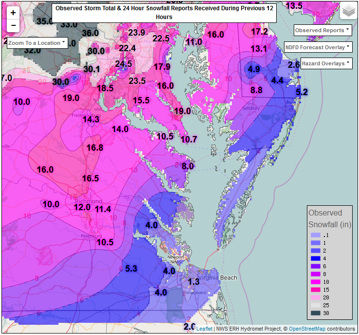
This change from snow to rain did not occur for everyone on Delmarva. The freezing line, separating the snow and rain, shown in the third picture at 9 PM on Friday night, moved above Wicomico County and stayed there until close to 1 PM Saturday. The freezing line then slowly moved back down and most of the peninsula began to see snow once again. This period of snow added another 2 inches of snow to the Salisbury total. Areas north of the freezing line continued to receive snow through Friday night and into Saturday, until the snow stopped close to midnight.
This story line helps put together the snow totals map. Areas that were north of the freezing line throughout the entire storm received up to 17 inches. The areas that received snow until midnight on Friday and then again Saturday afternoon received close to 8 inches. Lastly, areas that received more rain in the southern part of the peninsula only received 1 to 3 inches of snow.
The forecasted snow totals (in the second picture) and actual snow totals (the first picture) are similar, mainly due to the correct timing of the freezing line. We were expecting snow from the time the system moved in until around 10-12 PM on Friday night and then expected it to change back into the snow early Saturday afternoon as the system exited the region.
Coastal Flood and Blizzard Warnings were in effect throughout the weekend on the peninsula due to high winds. Most of the area had sustained winds from 20-35 mph gusting even higher, causing little to no visibility on the roads and flooding, mainly during the high tides on Saturday morning. Here is a look at of some of the highest wind gusts on the peninsula:
..DELAWARE…
DEWEY BEACH: 75
LEWES: 64
SUSSEX COUNTY AIRPORT: 64
BISHOPVILLE 17 NNE: 62
BIG STONE BEACH 18 SE: 60
…MARYLAND…
WEST OCEAN CITY 1 SE: 62
MUMFORDS LANDING: 61
SALISBURY: 58
…VIRGINIA…
WALLOPS ISLAND: 69
CHESAPEAKE BAY BRDG TUNNEL: 60