Are you Dreaming of a Record Warm Christmas?
After breaking record highs three days in a row this past weekend, Delmarva could be in for another round of very warm weather just in time for Santa on Christmas.
In weather, there are troughs (dips in the jet stream that bring cold air) and there are ridges (the jet stream is pushed north allowing warmer air to move in). During Christmas week, a strong and persistent Southeast Ridge will form across the region. A Southeast Ridge is a ridge that sets up across the Southeastern United States and it can push north into our area. This ridge appears to be unusually strong and could bring record high temperatures to Delmarva again on Christmas Eve and Christmas Day.
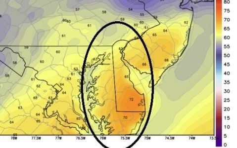
Every computer model agrees that temperatures will be above normal most of Christmas Week (60s, close to 70), but some are showing temperatures reaching and surpassing record highs (70s+). This would mean Delmarva could hit the 70s again. Below is what one model is showing for Christmas Eve on Delmarva.

The record high for Christmas Eve in Salisbury is 70 degrees and the record high for Christmas Day is 73 degrees. It looks like we may come quite close to that each day. As Dolly Parton and Kenny Rogers would sing, it may be “a Christmas to remember with springtime feelings in the middle of December.” But they weren’t talking about the actual temperature, were they?
A couple things will determine whether we get that warm or not. One will be the strength of the Southeast Ridge and the other will be the amount of rain that falls. Computer models are also showing a cloudy and unsettled Christmas week which could hold down temperatures.

Right now, Tuesday night into Wednesday look pretty wet on Delmarva. Christmas Eve and Christmas Day are still questionable. Stay tuned because so far this December is quite historical and my gut says we will make history again on Christmas.